
The present brutal effort by Russia’s Putin to bend another sovereign nation to his will is appalling to witness in the 21st century. Unfortunately, history is strewn with such examples of powerful nations using military might to exert domination over weaker neighbours. Despite blatant mismatch, they often justify the resulting brutality by claiming they were themselves threatened. The Low Countries and Poland are two examples in Europe where locals achieved periods of self-determination, often interspersed with dark periods of domination by continental powers from Spain to Russia.
Though little-known, Britain had its own equivalent a millennium ago. After it coalesced as a kingdom in the 10th and 11th centuries, had England been content within its frontiers, history might have taken a different course, especially in the Scottish Borders. Instead, English ambitions in all directions—France, Ireland, Wales and Scotland, had a long-lasting impact on those borderlands involved. What is now a rolling rural idyll along the River Tweed might have become home to two great cities and their hinterlands.
The Merse is the name given to that broad sweep of fertile land from the Eildon Hills to the North Sea, watered by the Tweed and bounded by the Lammermoors to the North and the Cheviots to the South. When the Romans arrived two thousand years ago, they wisely made peace with the powerful Selgovae and Goddodin ensconced in their hill forts. By the 7th century, the Romans were gone and the Kingdom of Northumbria had extended its power all the way to the Forth.
Berwick was founded as an Anglo-Saxon settlement. When Northumbria was annexed by the growing Kingdom of England in the 10th century, it lay in the area between Forth and Tyne contested by the expanding Kingdom of Scotland. The Merse and Berwick became Scottish after King Malcolm won a battle at Carham in 1018, after which the English became preoccupied with France and their new Norman heritage.
These growing kingdoms were financed by growing trade. Given the difficulty of overland travel, trade was largely a matter of shipping. Scotland, having abundant raw materials like timber, coal and wool was soon trading these for finished goods, wine and cloth with Hanseatic ports and booming Low Countries ports like Amsterdam, Antwerp and Bruges, East coast ports from Aberdeen down to Berwick carried on a trade with the, providing an important source of income to the Scottish crown. During the reign of David I (1124-1153) it was made a Royal Burgh. By 1153, Berwick boasted walls, a mint, a castle, and a hospital. Its Constables included several Lauders of the Bass. Their writ ran south of the Tween to include Ancroft, Kyloe Norham, Belford, Elwick and Tweedmouth, as well as present-day Berwickshire.
With its natural harbour in the broad tidal estuary, Berwick became the most important of these because of the variety of goods produced by the fertile Merse. These goods were floated down the Tweed, as there were no adequate roads. This drove a need for a entrepot on the upper Tweed where these goods could be assembled and stored for transport.
This gave birth to Roxburgh, a bustling town, strategically placed at the confluence of the Teviot and Tweed. Laid out on the flat water meadow between, it was protected by both rivers and a hill at the narrow neck between. This position on the upper Tweed, together with South Berwick (so named to distinguish it from North Berwick in East Lothian) defined Scotland’s southern border.
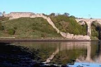
Because of a substantial trade with the Continent, both towns grew prosperous ad, together with Edinburgh and Stirling, formed the four main cities of Scotland in the early Middle Ages. As well as mint and merchants, like those other cities, they could afford stone castles. The one in Berwick overlooked the Tweed at the southern end of the walls and now lies under the railway station and the approach to the Border Bridge. Standing on a defensible peninsula between the rivers with Roxburgh Castle was built on the hill guarding the narrow neck between the rivers.

David I also conferred Royal Burgh status on Roxburgh. Its zenith spanned three centuries between the reigns of William the Lion (1165-1214) and James II (1437-1469). It prospered and was also the site of a Royal Mint, boasting three churches, two main streets, lined with merchants and craftsmen and schools which were run by the monks of Kelso Abbey, across the river.
Roxburgh’s prosperity was exceeded by Berwick’s, leading to border unrest. A succession of raids, sieges and takeovers followed. William I of Scotland tried to pre-empt this by attempting to capture Northumberland as a buffer zone in 1173–74. After his defeat, Berwick was ceded to Henry II of England., but It was later sold back to William by Richard I to raise funds for his crusade.
Things became even more unstable when Edward I, having conquered Wales, came north with ambitions to similarly subjugate Scotland in 1296, whereupon the long decades of the Wars of Independence regularly interfered with trade, most especially when the English held Berwick during one of the 13 times it changed hands.
English and Scots forces repeatedly captured and recaptured both towns. During his occupation of Scotland, Edward I of England resided at Roxburgh Castle, spending his birthday there. The castle was besieged several times, notably in 1314, in the run-up to Bannockburn.
In these border disputes, the Scots were at a strategic disadvantage. The economic heartland of England lay far to the south, in the fertile fields of Lincolnshire and East Anglia—well out of reach of border raiders and even armies penetrating far into England. The English, on the other have, needed only to cross the border and besiege Berwick or Roxburgh to cripple half of Scotland’s trade and wealth. And each time Berwick was held by the English, Roxburgh started to wither on the vine, even if it remained unmolested itself.
While both towns were in Scottish hands and England was pre-occupied elsewhere, riches flowed. The 150 years of the Hundred Years War in France and the Wars of the Roses blessed both towns and Scotland flourished. But once those were concluded in the late 15th century, the English turned on the rest of the British Isles, whereupon things went pear-shaped for the Merse.
By 1460, Roxburgh was in English hands, followed by Berwick, which changed hands for the last time in 1482 when it was captured by Richard III. As Berwick occupied a strategic location on the coast that could threaten the Scottish Lowlands and be supplied by sea, it was fortified, most notably by Elizabeth I with magnificent city walls that exist intact to this day.
Roxburgh, on the other hand, was abandoned by the English as too isolated. However, since it had permanently lost its port access to the world, it withered and died as a settlement. As virtually all the buildings were wood, there is now barely a trace of the town that once stood between the rivers. A Time Team excavation discovered where the two main streets and many buildings once lay. But all that remains to be seen are some crumbling remnants of stone ramparts that once was Roxburgh Castle, hidden amidst the tees that now crown the hill. And whether Roxburgh could have been another Bruges or Berwick another Amsterdam remains the realm of fiction and imagination.
#1010—1,228 words
