
(Note: this is the column I would like to have written for my local paper, The East Lothian Courier, but was constrained to half the words and neither of the maps)
The new agreement between the SNP and Greens to govern Scotland in a loose coalition comes none too early for our environment. Both parties have displayed good environmental credentials. This makes the goal of carbon-neutrality by 2045 all the more plausible. However, even if this goal is reached, there is no guarantee that other, far more prolific greenhouse gas emitters will follow suit.
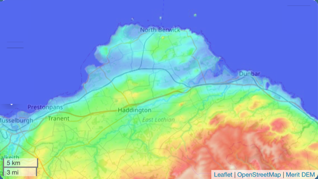
Look at any Admiralty chart or decent shoreline map and you find a line wriggling between land and sea marked “MHWS”. Those living along the coast know the tides don’t just come in and go out twice a day, but the amount varies between “Neap” (small) and “Spring” (large) tides. Along East Lothian’s coast, tides vary between a 2m and 6m difference between extremes. HWMS (High Water Mean Springs) shows how high up the beach the sea gets at high tide. Its position is changing—for the worse.
The problem of global warming is likely to continue and worsen. The 1.5 – 2.0 degree C temperature rise will almost inevitably lead to sea level rising over the next few decades. Research by Climate Central, made up of leading scientists and journalists who research climate change and its impact on the public, have predicted some serious coastal flooding in Scotland by 2050.
As the planet warms, seas expand, glaciers and (especially) massive, thick ice sheets high out of the water on Greenland and Antarctica melt, adding volume to raise sea level. It took the 19th and 20th centuries to add 20 cm to sea level. It took the last 20 years to add another 5 cm. The next three decades are expected to add 10 cm, 20 cm and 30 cm, respectively as warming accelerates. The total of less than 1m may not sound much, but other factors are involved.
NASA’s Sea Level Change Science Team at the University of Hawaii have highlighted a factor liable to make things worse before 2040. The Moon, which causes tides, has an 18.6-year cycle during which it “wobbles” This suppresses the height of high tides for half that cycle (which we are now entering) and amplifies them for the other. The next amplification, reaching perhaps an additional 10 cm, will be during the 2030s.
Timing is uncertain because several factors need to combine to boost unusually high tides so that they cause major flooding and damage. And “damage” need not mean going permanently under water. Fields, installations properties do not need to be flooded more than a few times for them to become useless and abandoned. Haughs and links will become salt marsh or mud flats; beach front properties will become derelict or protected by dykes that block views of the sea.
In the local area of East Lothian’s coast, very little will be permanent inundated. Even with a storm surge adding to unusually high spring tides, that extra metre will not reach places like Port Seton, Gullane, most of Dunbar or Prestonpans because they all sit at a slight elevation. But there are some vulnerable points.
It is clear from the map that Aberlady and Belhaven Bays will see the largest are permanently lost to the sea. This will mostly be farmland at Saltcoats, Luffness, Hedderwickhill, Tynemount, Kirklandhill and Knowes. What this does not make clear is that two key pieces of vital infrastructure—Torness power station and North Berwick sewage works will need special defences if they are not to be flooded and abandoned, probably well before 2050.
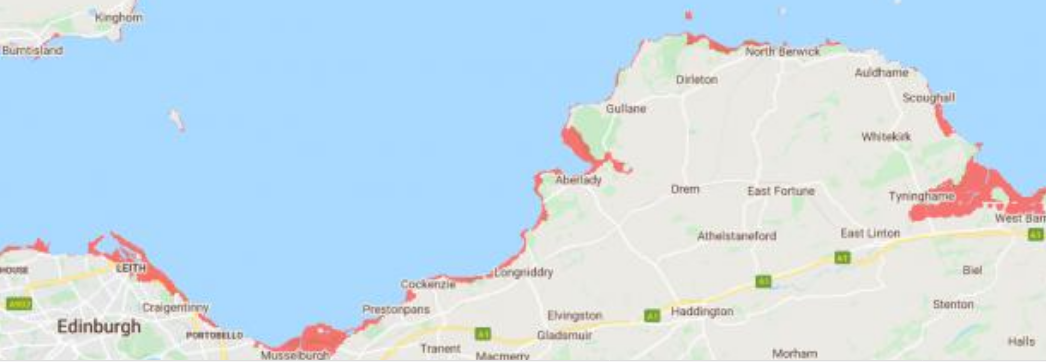
Low-lying parts of coastal towns like North Berwick’s Low Quay, Aberlady’s Gullane Road, Tyninghame’s South Row or the Belhaven and West Barns Inn areas will be threatened with no easy solution for defence. Worst hit will be the Fisherrow and Goose Green areas of Musselburgh on either bank of the Esk as it enters the Forth. Proportionally, recreation will ne hardest hit , with Musselburgh Ash Lagoons, Racetrack and Old Golf Course, East Links Country Park, Foxlake, plus links golf courses at Luffness, North Berwick West. There seems no obvious affordable way to defend any of these.
Of you think this is bad at one metre, the future could be much worse. There is enough ice piled on Greenland and Antarctica to add more than another 50 metres. Flooding at that level would leave Berwick Law an island and Tranent, the only town left in East Lothian, would be coastal.
Should sea levels continue to rise, Musselburgh—the largest town in East Lothian and the one already hardest hit—will lose a great swathe from Levenhall though the Wimpeys, the town centre and the rest of Fisherrow, causing massive property loss. Funds on a scale to prevent this may not be available, as elsewhere—Clydeside, Grangemouth, Leith, Ardrossan, Stirling, Inverness and others—will al be threatened even more. London, New York, Amsterdam, Singapore, Venice, etc. all face the same problem.
If that isn’t incentive enough to take global warming seriously and hope the SNP & Greens can get their (and, subsequently, our) act together, then what would be?

Pingback: Is It a Fair COP? | davidsberry