
Once upon a time, the British took the Phoenecian and Viking idea of building a maritime empire to its logical global conclusion. We spent the last two centuries congratulating ourselves on how clever we were to do so. Leave aside that a former colony has long put us in the shade as the heavyweight of global enterprise; leave aside that the masses of goods imported into the UK (we’re not so good at exporting any more) arrive in non-British ship bottoms, registered under flags of convenience from Panama to Liberia, not the Red Duster; we still remain a maritime nation.
Which means that we still should pay attention to what goes on on those high seas we rely on. We should keep our wits about us to counter threats and exploit opportunities. But, unfortunately, media and government thinking both seem increasingly landlocked and focused on landlubber issues like Palmyra, Ukraine or Brussels.
Non-terrorist threats not requiring immediate action get short shrift. One such ho-hum is global warming and its effect on global ice sheets. This has drifted in the background of people’s awareness for years. Deniers do their best to keep it there. But since 3,250 sq km of the Larsen B ice shelf in Antarctica—a chunk of floating ice the size of Lothian— went walkabout in 2002, some people have sat up. Recent research doubles the prevailing estimate of rise in sea level by 2100AD from 1m to 2m .
This is reinforced by mappings of the extent of Arctic ice at the end of each summer. The deterioration seems a cruel joke on intrepid explorers like Cabot, Frobisher and Davis who searched for the Northwest passage in vain; it now exists, albeit seasonally. Compare the two maps below for 1979 and 2011. The coloured line shows average extent for the period.
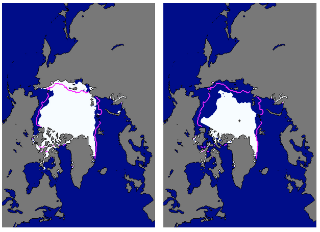
In recent seasons, ships have traversed round both sides of the remaining ice pack. And the way things are going, its extent will shrink further, possibly disappearing. Even though it would refreeze each winter, icebreakers could traverse it part of the time because it would be thin while forming.
This happening would not imply global inundation. The huge Greenland and West Antarctic ice sheets sit on land and their melting would indeed be catastrophic. If that happens, we need gills: Glasgow’s underwater and the Highlands become two islands. But Arctic ice already floats on water and displaces almost the same volume when melted. We might in fact find some good out of such an event. Look at the maps again and, this time, from a truly global perspective.
European trade with the Far East, especially China, has mushroomed in recent decades. Unless we find a better source of cheap electronics, appliances and manufactured goods, will grow more. At present, virtually all of this arrives in massive container ships. Where these were once so-called ‘Panamax’ size—cargo of around 80,000 tons (carrying 4,000 20ft containers) that could fit through the Panama canal—trade is moving to ‘Post-Panamax’ (6,000 containers) and ‘Post-Panamax Plus’ (10,000 containers). While the latter is more efficient for the $14m it costs to run (vs $9m for a Panamax), over half that cost is fuel.
The reason it costs so much is the distance. Glasgow may be just over 5,000 air miles from Shanghai but even ships using the Suez canal cover 10,800 miles and take over a month to get there. Larger ships must cover the Cape route’s 14,100 miles and that takes six weeks because ‘Slow Steaming’ at around 18 knots is the standard way to save expensive fuel. If that distance could be halved, then fuel worth $8m could be saved each voyage and twice as many voyages made. So let us really look at those maps again.
Even if the Arctic were not entirely clear of ice, 6,000 miles Glasgow to Shanghai becomes a possibility for perhaps half the year. What Europe really would need is a trans-shipment port. Huge vessels have great trouble accessing the shallow ports of Hamburg, Rotterdam, Felixstowe, Le Havre, etc. But they could be loaded up from and discharge to small ‘feeder’ cargo ships in some large, deep water anchorage on the edge of Europe for distribution..
I give you the 324 sq km (same size as the lost Larsen B) of water that is Scotland’s Scapa Flow and a peaceful reincarnation of the Arctic Convoys of WW2.
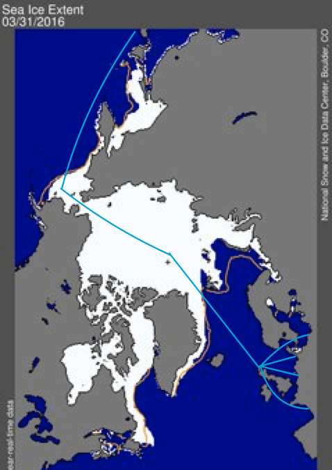
This map shows the sea ice at the beginning of this month—the greatest extent likely in the foreseeable future. Even assuming all of it does not melt, there will be open water and the advantage of this route as sea lanes is obvious. Once the home of the Royal Navy’s Grand Fleet of battleships, Scapa Flow, already a major oil terminal, could become what Patterson once dreamed of in his ill-fated Darien scheme of 1698—a major global entrepôt that would transform the economy of Scotland and place it at the heart of world trade.

Pingback: The Road to Scindy V—Rebuilding Ambition | davidsberry